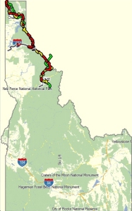
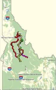
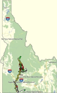

Above, ICT broken into three Regions –
Upper, Central, Lower.
The full mapset lists 6700+
waypoints and 600+ tracks that comprise the main routes, alternate routes,
and nearby off-trail routes that
might be useful for resupply, self-location, and bailing.
The right-most map is the First Draft
of the White Line map.
This Map is focused on the primary course
and several highly probably alternate/parallel routes for better
travel (ie.
bicycle), connections to resupply locations, and locating important bridges.
This map is comprised
of 2300+ waypoints showing most
trail junctions and the 200 route segments that are the ICT.
All maps are drafts.
Ninety percent of the trail segments on all maps are identified by their
official trail number
& name, and road number & local
name; with the White Line map being 99% complete and double checked.
Mile marks serve as an excellent reference but
there is no correlation to any other source.
In these draft versions
Waypoint Naming uses the last crossed mile mark and
therefore are possibly greater than a half-mile ‘wrong’.
Mapout is currently my mapping app of
choice. These .gpx files can be mailed
directly from me to your copy of the
Mapout app on your phone. I have not worked on the mis-matched icons
between Garmin and Mapout.
Send an email for the .gpx files.
ICT.data@gubbool.org.
........
Visit the other site for conversation
on this trail, if any, ever: lifeat2mph.com
Idaho
Centennial Trail - Download gpx or kmz data for gps or google earth